Why In News?
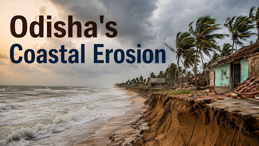
A comprehensive shoreline change assessment (1990–2022) by the National Centre for Coastal Research (NCCR) found that 28.3% of Odisha's coastline is under erosion, while 54.1% is witnessing accretion and 17.6% remains stable.
What Is Coastal Erosion?
-
Coastal erosion means the progressive loss of land along a shoreline due to wave action, currents, and tides.
-
It involves shoreline retreat, where the land-sea boundary moves inland over time.
-
Sediment loss occurs when sand and material are removed faster than they are replenished.
-
Some erosion follows natural coastal processes, such as wave energy and longshore currents.
-
Much of today's erosion also reflects human-induced coastal change, including port construction, sand mining, and embankments.
Why Is Odisha Vulnerable to Coastal Erosion?
-
Odisha has a long coastline of 564 km, exposing it to extensive erosion risk across multiple districts.
-
The state faces a disproportionate share of India's cyclones, given its location on the Bay of Bengal.
-
Sea-level rise, linked to global warming, is gradually submerging low-lying coastal stretches.
-
High wave energy along parts of the coast accelerates sediment removal.
-
Storm surges during cyclones cause sudden, severe erosion episodes.
-
River sediment changes, partly from upstream dams and embankments, reduce the natural sediment supply that would otherwise replenish beaches.
-
Human intervention, including port development and coastal construction, disrupts natural sediment transport patterns.
Major Causes
-
Sea-level rise steadily pushes the shoreline inland across low-lying stretches.
-
Stronger coastal hazards, including more frequent and intense cyclones, accelerate erosion during extreme events.
-
Reduced sediment supply results from upstream river interventions that trap sediment before it reaches the coast.
-
Port and harbour development, such as construction activity at Paradip Port, has been linked to erosion impacts in neighbouring Jagatsinghpur and Kendrapara stretches.
-
Sand mining along beaches and riverbanks directly removes material needed for natural coastal buffering.
-
Coastal infrastructure, including roads and embankments, can alter natural wave and sediment dynamics.
-
Destruction of natural barriers, particularly mangrove and dune loss, removes protection that would otherwise absorb wave energy.
Climate Change Is Increasing the Risk
|
Impacts of Coastal Erosion
Land Loss: 33.6% of India’s mainland coastline experienced erosion during 1990–2018, threatening coastal land, habitats and settlements (Source: NCCR)
Livelihoods: Erosion reduces fishing space, boat-landing areas and tourism assets, directly affecting coastal communities.
Infrastructure: Shoreline retreat threatens houses, roads, ports and coastal industries; harbours, beach mining and dams can further alter sediment flows.
Disaster Risk: Erosion removes the natural coastal buffer, increasing exposure to storm surges, cyclones and sea-level rise.
Ecological Loss: Erosion degrades beaches, dunes, wetlands and mangroves, weakening biodiversity and natural coastal protection.
Salinity: Shoreline retreat can intensify saltwater intrusion, affecting coastal groundwater and agricultural soils.
Displacement: Erosion causes asset loss and relocation pressure; the 15th Finance Commission recommended support for erosion mitigation and resettlement.
Regional Hotspots: During 1990–2022, erosion affected 58.3% of Valsad and 60.3% of Navsari coastline. (Source: NCCR)
Framework to Manage Coastal Erosion
Scientific Mapping: NCCR uses remote sensing and field surveys to identify erosion-prone stretches and prepare Shoreline Management Plans (SMPs).
Hazard-Line Planning: India’s Hazard Line maps long-term risks from erosion, flooding and sea-level rise, supporting disaster-resilient coastal planning.
CRZ Regulation: CRZ Notification 2019 regulates development in sensitive coastal zones and requires States/UTs to update Coastal Zone Management Plans.
Integrated Management: NCSCM promotes Integrated Coastal Zone Management (ICZM) combining ecological conservation, livelihoods, spatial planning and scientific assessment.
Nature-Based Protection: India is developing green coastal infrastructure using sediment cells, hazard mapping and nature-based solutions instead of relying exclusively on hard structures.
Site-Specific Engineering: NCCR supports location-specific interventions; Puducherry and Chellanam demonstrate beach restoration and flood-risk reduction through targeted coastal protection.
Disaster Financing: 2024 guidelines provide ₹1,500 crore for 2021–26 for coastal/river erosion mitigation and resettlement under NDMF/NDRF mechanisms.
Community Resilience: NDMA’s ICRMRP integrates risk assessment, early warning, ecosystem resilience, community capacity and sustainable spatial planning.
Adaptive Governance: India follows a “Map → Monitor → Regulate → Restore → Protect → Relocate” approach, combining SMPs, CRZ enforcement, ecosystem restoration and risk-based relocation.
Challenges In Managing Coastal Erosion
-
Dynamic coastline: Erosion varies across sediment cells and seasons, making uniform engineering solutions ineffective.
-
Data–implementation gap: India has national hazard-line and shoreline mapping, but translating these into local land-use decisions remains difficult.
-
Hard-structure externalities: Seawalls and groynes can interrupt sediment movement and shift erosion to adjoining stretches.
-
Competing land uses: Ports, tourism, fisheries, settlements and conservation compete for limited coastal space, complicating integrated planning.
-
Climate uncertainty: Sea-level rise and changing wave intensity can alter existing erosion patterns, requiring adaptive rather than fixed interventions.
-
Fragmented governance: Coastal management involves multiple ministries, States, local bodies and sectoral agencies, creating coordination and jurisdictional gaps.
Way Forward
-
Data-led planning: Update Shoreline Management Plans using satellite monitoring and sediment-cell mapping.
-
Nature-based protection: Restore mangroves, dunes and beaches before hard structures; Puducherry project restored 1.5 km of beach after 30 years.
-
Site-specific engineering: Use submerged reefs, nourishment or dykes only after sediment and wave studies; Kadalur Periyakuppam’s submerged dyke protected 3 fishing villages.
-
Integrated governance: Link CRZ, Hazard Lines, CZMPs and SMPs with local land-use planning to prevent new settlements in high-risk stretches.
-
Secure funding: Implement the ₹1,500-crore NDMF framework for 2021–26 covering coastal/river erosion mitigation and resettlement.
-
Community resilience: Combine coastal protection with fisher livelihoods and early-warning systems; NCCR’s Thoondil app provides hazard information to Tamil Nadu fishers.
-
Adaptive institutions: The 2026 MoES–Puducherry MoU creates Joint Working Groups and annual reviews for coastal resilience, offering a model for continuous Centre-State coordination.
-
Managed retreat: Repeatedly eroding settlements should receive relocation plus livelihood restoration rather than perpetual reconstruction, supported through the NDMF/NDRF framework.
-
Community-led resilience: Integrate fisher communities into planning, monitoring and livelihood diversification, making coastal protection socially acceptable and locally sustainable.
Conclusion
Odisha's rising coastal erosion demands integrated, community-centred climate adaptation, not just sea walls and embankments.
Source: INDIANEXPRESS
|
PRACTICE QUESTION Q. Discuss the major causes of coastal erosion in Odisha. Examine why nature-based solutions are considered more sustainable than hard engineering measures alone. (250 words) |



