Why In News?
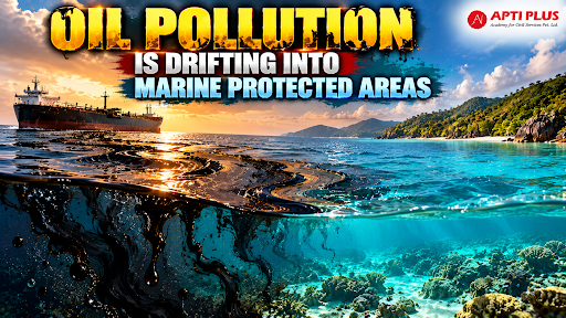
A satellite investigation by SkyTruth found that oil slicks from shipping and offshore activities frequently enter marine protected areas, endangering marine wildlife.
What Is An Oil Spill?
An oil spill refers to the accidental or operational discharge of liquid petroleum hydrocarbons into marine or coastal environments, originating from oil tanker collisions, drilling rig blowouts, pipeline ruptures, and vessel bilge dumping.
-
Crude oil contains toxic mixtures of Polycyclic Aromatic Hydrocarbons (PAHs), heavy metals, volatile organic compounds, amines, and sulfur compounds that persist in aquatic environments.
-
Upon release, spilled oil undergoes weathering processes—including evaporation, emulsification, photo-oxidation, and natural dispersion—shifting from light iridescent sheens to toxic, viscous asphalt pavements.

What Is The Scale Of Global Marine Oil Spill Pollution?
Global Surface Slick Area: Satellite mapping by SkyTruth reveals that routine operational discharges and accidental spills cover nearly 1.6 million square kilometers of ocean surface annually.
Primary Pollution Sources: Vessel operational discharges—such as illegal bilge water dumping and cargo hold washing—account for 81% of global oil slick coverage, while offshore oil platforms and pipeline infrastructure contribute 18%.
Historical Spill Discharges: Between 1970 and 2023, an estimated 629 major spill events released over 1,522,000 tonnes of oil into marine waters, with oil tanker accidents accounting for nearly 45% of global spill volume.
High-Density Hotspots: European waters record chronic pollution; the North Sea receives between 15,000 and 60,000 tonnes of oil from 3,000 illegal dumps annually, while the Mediterranean Sea experiences 1,500 to 2,000 spill incidents every year. High-density transit zones like the Strait of Malacca remain persistent pollution corridors.
Incursion into Protected Waters: Satellite data confirms that chronic oil slicks repeatedly drift into Marine Protected Areas (MPAs), overlapping 15% of global coral reefs, 63% of seagrass meadows, and 15% of coastal mangroves in frontier development blocks.
How Do Oil Spills Degrade Marine Ecosystems?
Thermal Loss: Heavy crude and fuel oils coat seabird plumage and marine mammal fur, destroying waterproofing and insulation properties, which leads to fatal hypothermia or overheating.
Bioaccumulation: Toxic PAHs bioaccumulate in phytoplankton and zooplankton, causing cell deformities, reduced photosynthetic activity, altered feeding behaviors, and egg cell disruption. Ingested oil induces gastrointestinal lesions, renal failure, and hemolysis in sea turtles and seabirds.
Destruction of Vulnerable Coastal Habitats:
-
Mangrove Forests: Heavy oil coats prop roots and blocks aerial root breathing pores (lenticels), causing plant asphyxiation and mass die-offs, while light oil fractions disrupt plant salt-balance mechanisms.
-
Coral Reefs: Floating and dispersed oil blocks sunlight penetration, elevates water temperatures, impairs gas exchange, and causes chronic reproductive failure in coral colonies.
-
Seagrass Meadows & Saltmarshes: Hydrocarbon entrapment in anaerobic mud sediments causes persistent toxic retention and loss of blue carbon storage capacity.
Food Web Collapse: Destruction of primary producers and benthic invertebrates (crabs, plankton, shellfish) creates cascading ecological failure across marine food webs, threatening endangered species such as the Irrawaddy dolphin (Orcaella brevirostris), proboscis monkey, and sea turtles.
What Are The Emerging Technological Innovations For Oil Spill Detection And Cleanup?
|
Technology Category |
Innovation / Model |
Mechanism & Key Features |
Operational Advantage |
|
Space-Based Remote Sensing |
SAR & Multi-Spectral Satellite Sensors |
Active Synthetic Aperture Radar (SAR) (e.g., Sentinel-1, ALOS PALSAR) detects surface wave dampening caused by oil; optical sensors (Sentinel-2, MODIS) measure light absorption across blue and shortwave-infrared (SWIR) bands. |
Operates 24/7 through clouds, fog, and darkness; provides wide-area ocean surveillance. |
|
AI & Computer Vision Detection |
OilSAM2 Framework |
Memory-augmented Segment Anything Model 2 (SAM2) featuring a hierarchical memory bank (texture, structure, semantic) and a structure–semantic consistent update strategy. |
Delivers state-of-the-art segmentation accuracy (~84% mIoU) on unordered SAR image collections while preventing semantic drift. |
|
Automated Vessel Correlation |
Cerulean Platform (SkyTruth) |
Integrates Sentinel-1 SAR imagery with Automatic Identification System (AIS) transponder data using machine learning algorithms. |
Automatically matches detected oil slicks with specific vessel tracks or platforms to hold polluters accountable. |
|
Autonomous Robotics Fleet |
Multi-ASV Fleet Management |
Fleets of boom-towing Autonomous Surface Vehicles (ASVs) coordinated via Mixed-Integer Linear Programming (MILP) routing and feedback-linearization path controllers. |
Optimizes multi-spill containment routes based on risk-weighted latency, enabling rapid nearshore recovery without crew risk. |
|
Advanced Nanomaterials |
Superhydrophobic & Magnetic Sorbents |
Oleophilic aerogels, magnetic nanoparticles, and superhydrophobic sorbents that selectively absorb hydrocarbons while repelling water. |
Delivers high sorption capacity and enables simple, automated magnetic retrieval of spent sorbents. |
|
Enhanced Bioremediation |
Synergistic Microbial Consortia |
Combines biostimulation (nutrient enhancement) with bioaugmentation (deploying biosurfactant-producing bacteria alongside hydrocarbon degraders). |
Accelerates natural biodegradation of oil plumes without leaving persistent toxic synthetic chemical residues. |
|
Slick Thickness Estimation |
SAR Contrast Ratio Algorithms |
Algorithmic analysis of radar backscatter contrast ratios to map oil slick thickness variations. |
Distinguishes thin sheens from heavy crude accumulation, enabling targeted deployment of recovery assets. |

Conclusion
Combining AI-driven satellite surveillance, autonomous cleanup robotics, and strict statutory liability under integrated coastal management is vital to safeguard marine ecosystems and ensure long-term socio-ecological ocean resilience.
Source: MONGABAY
|
PRACTICE QUESTION Q. With reference to the ecological impact of marine oil spills, consider the following statements:
Which of the statements given above are correct? (a) 1 and 2 only (b) 2 and 3 only (c) 1 and 3 only (d) 1, 2, and 3 Answer: C Explanation: Statement 1 is correct: When an oil spill occurs, crude oil forms a thick, floating layer on the surface of the water. This layer acts as a physical barrier that restricts the penetration of sunlight into deeper water columns. Because coral reefs rely heavily on sunlight to power the photosynthetic processes of their symbiotic zooxanthellae algae, this reduction in light directly impedes photosynthesis and disrupts the ecosystem's baseline balance (homeostatic plateau). Statement 2 is incorrect: Eutrophication and massive harmful algal blooms are primarily triggered by the accumulation of excess agricultural fertilizers, industrial discharges, or domestic sewage containing nitrates and phosphates. Marine oil spills introduce hydrocarbons (organic compounds composed of carbon and hydrogen) rather than agricultural nutrients. In fact, large oil slicks generally hinder algal growth by blocking light, though they can sometimes indirectly trigger localized shifts in microbial populations when zooplankton grazers die. Statement 3 is correct: The physical properties of crude oil are devastating to marine wildlife. When oil coats sea birds and fur-bearing marine mammals (such as sea otters), it destroys the natural alignment and waterproofing properties of feathers and fur. This eliminates their ability to trap air for thermal insulation, exposing their skin directly to cold ocean waters and making them highly susceptible to fatal hypothermia. |