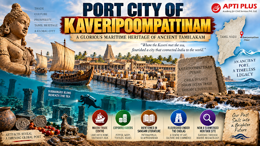
Why In News?
The Tamil Nadu State Department of Archaeology (TNSDA) launched the 3rd Phase of deep offshore underwater archaeological exploration off the coast of Poompuhar to map submerged Sangam-era port structures.
What is Kaveripoompattinam?
Ancient Capital Port: Kaveripoompattinam (also known as Poompuhar or Puhar) served as the secondary capital, coastal emporium, and royal port of the Early Chola Kingdom during the Sangam Age (circa 3rd century BCE to 3rd century CE).
Location: Situated along the Coromandel Coast in present-day Mayiladuthurai district (formerly Nagapattinam district) of Tamil Nadu, at the confluence where the sacred Kaveri River enters the Bay of Bengal.
Nodal Maritime Hub: Positioned at the crossroads of trans-oceanic Indian Ocean trade routes connecting the Roman Mediterranean in the West with Sri Lanka, Southeast Asia (Suvarnabhumi), and Han China in the East.
Significance in Sangam Traditions
-
Poompuhar serves as the foundational narrative setting for Ilango Adigal’s celebrated Sangam epic Silappadikaram, recounting the lives of the wealthy merchant Kovalan and his virtuous wife Kannagi.
-
Buddhist Legacy in Manimekalai: Described in Seethalai Sathanar's Buddhist epic Manimekalai, noting its cosmopolitan monastic quarters, annual Indra festival (Indra Vizha), and ultimate submergence by the sea.
-
Vivid Commercial Portrayal in Pattinappalai: The Sangam anthology poem Pattinappalai (composed by poet Kadiyalur Uruttirangannanar in praise of Chola king Karikala) details the urban layout of Puhar:
-
Two Distinct Quarters: Divided into Maruvurpakkam (the busy maritime harbour quarter near the sea inhabited by sailors, foreign merchants, and craftsmen) and Pattinappakkam (the inland royal residential quarter with broad avenues, palace gardens, and administrative mansions).
-
Customs Warehouses: Packed with imported goods stamped with the Chola royal Tiger Emblem (Puli Kodi) before duty clearance.
-
Cosmopolitan Foreign Merchants: Mentions foreign merchants speaking diverse tongues (Yavanas—Greeks and Romans) living in harmony with native Tamil traders.
-
Greco-Roman Literary Corroboration: Referred to as "Khaberis Emporion" by the Alexandrian geographer Claudius Ptolemy (2nd century CE) and referenced in the anonymous maritime guide The Periplus of the Erythraean Sea.
What Evidence Supports Poompuhar’s Maritime Importance?
|
Excavation |
Archaeological Findings |
Historical Significance |
|
Kilaiyur Onshore Excavations (ASI, 1960s) |
Semi-circular brick dock/wharf structure with wooden mooring posts carbon-dated to ~300 BCE. |
Conclusive physical proof of an engineered tidal river dock for loading merchant vessels. |
|
Vanagiri Intertidal Explorations |
Submerged dressed stone masonry blocks, brick courses, and ring wells exposed at low tide. |
Represents residential quarters and defensive breakwaters submerged by coastal erosion. |
|
Poompuhar Offshore Underwater Surveys |
Horseshoe-shaped stone structures at 5–8 meters depth and ancient shipwreck anomalies. |
Suggests intentional harbour wall construction or submerged monumental temples. |
|
Poompuhar Site Museum Artefacts |
Roman amphorae sherds, rouletted ware, square copper Chola coins (tiger obverse, elephant reverse). |
Confirms direct maritime trade linkages with the Roman Empire and Southeast Asia. |
|
Lead and Metal Ingots |
Inscribed lead ingots recovered from submerged shipwrecks bearing Brahmi characters. |
Confirms thriving export-import metallurgy and trade monetization under the Cholas. |
What is Underwater Archaeology?
It is a branch of archaeology studying submerged cultural heritage—material remains of human settlements, harbour installations, and shipwrecks submerged beneath oceans, rivers, and estuaries.
-
Non-Invasive Acoustic Geophysical Exploration:
-
Side-Scan Sonar (SSS): Emits acoustic pings to generate high-resolution photographic-like imagery of seabed topography and structural mounds.
-
Sub-Bottom Profiler (SBP): Uses sound frequencies that penetrate marine sediments to reveal buried stone walls, wooden ship hulls, and palaeo-river channels.
-
Multibeam Echosounders (MBES): Produces 3D digital bathymetric terrain models of the continental shelf.
-
Marine Magnetometers: Detects magnetic anomalies caused by ferrous metals, anchor stocks, and iron cannonry on the sea floor.
Source: NEWINDIANEXPRESS
|
PRACTICE QUESTION Q. Consider the following pairs of ancient Indian ports and their associated regions: 1. Kaveripoompattinam — Coromandel Coast (Chola Kingdom) 2. Muziris — Malabar Coast (Chera Kingdom) 3. Korkai — Gulf of Mannar (Pandya Kingdom) How many of the pairs given above are correctly matched? (a) Only one pair (b) Only two pairs (c) All three pairs (d) None of the pairs Answer: (c) Explanation: 1. Kaveripoompattinam — Coromandel Coast (Chola Kingdom): Correct. Also known as Poompuhar, this was a major port city on the east coast of India (Coromandel Coast) and served as the capital and chief port of the early Chola Kingdom. It was a major hub for trade with Southeast Asia. 2. Muziris — Malabar Coast (Chera Kingdom): Correct. Located on the southwestern coast of India (Malabar Coast) in modern-day Kerala, Muziris was one of the most important ancient ports of the Chera Kingdom. It was famous for its brisk trade in black pepper and spices with the Roman Empire. 3. Korkai — Gulf of Mannar (Pandya Kingdom): Correct. Situated near the mouth of the Thamirabarani River along the Gulf of Mannar in modern-day Tamil Nadu, Korkai was an ancient port city and the early capital of the Pandya Kingdom. It was internationally renowned for its pearl fishery. |



